Flood Mitigation Project

Building a resilient future through natural and engineered solutions.
Project Update
Where are we now…
-
BayLand Consultants & Designers Inc. to complete design and permitting.
-
Initial surveying work and geotechnical borings to assess existing conditions has been completed.
-
Preliminary alignment, an initial step in the design process is underway. Review and comment is being sought.
-
Individual meetings with targeted shoreline property owners were conducted in March and April, 2025 .
-
A public outreach meeting for the review of the preliminary alignment was held on May 13, 2025. Feedback from this outreach process will inform the the next milestone in this process, which is 30% design.
-
The University of Maryland Center for Environmental Science (UMCES) at Horn Point is supporting the project and will optimize the design of the living shoreline and achievement of ecological co-benefits via living components of the project such as an oyster reef.
-
Grant funding from the National Fish and Wildlife Foundation has been award to support habitat enhancement. Habitat Enhancement & Green Stormwater Management public listening session held for the Gerry Boyle Park area on May 28, 2025.
-
The flood mitigation project and overall Make Cambridge Resilient initiative was presented to the Rotary Club on June 12, 2025. Information on flood risk, the flood mitigation project, and green stormwater management was shared with club members.
-
30% design presented and shared with:
-
the Stakeholder Group on August 5, 2025;
-
the Long Wharf Park Area residents and other interested community members on September 4, 2025 (focus of meeting was on the flood mitigation project specific to the Long Wharf Park area);
-
the Flood Mitigation Project Community Meeting at the Cambridge Branch of the Dorchester County Library on September 9, 2025; and,
-
the Mayor & Council work session on October 20, 2025.
-
-
In-person targeted property owner and design team meetings were held in October and November 2025 to discuss pier design options.
-
Additional public outreach including a visual model, a virtual living shoreline session, understanding flood risk and Maryland online tools "how to" YouTube videos, and additional project updates to the Mayor & Council were held in October & November 2025.
-
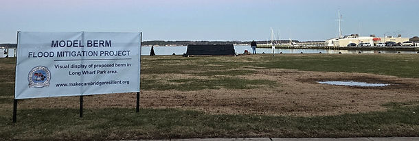
As requested by public meeting participants, a model berm will be constructed on December 2, 2025 in the duck walk area of Long Wharf Park. The model berm will be constructed to scale, using the dimensions included in the draft design. Signage and an information flyer will be available at the model berm.
-
A virtual education session on living shorelines has been scheduled on the evening of December 10, 2025. Presenters include representatives from the Maryland Department of Natural Resources and the University of Maryland, Center for Environmental Sciences at Horn Point.
-
60% design presented and shared with:
-
the Steering Committee on January 27, 2026; and,
-
the Flood Mitigation Project Community Meeting at the Cambridge Branch of the Dorchester County Library on February 24, 2026.
-
Design Complete
60%
Draft Flood Mitigation Design

Flood Risk Reduction & Nature Based Solutions
Climate Change Mitigation
Increased plantings
Vegetation or organic material in soils can help regulate Earth’s climate by removing carbon dioxide from the atmosphere.

Fisheries
Complex habitat (i.e., high rugosity) provided by Nature Based projects support higher levels of biodiversity and fisheries production than degraded or hardened shorelines.
(e.g., Scyphers et al. 2011; Humphries and La Peyre 2015; Gittman et al. 2016)

Habitat
Increasing local biodiveristy lost over the years is the number one co-benefit after flood risk reduction.

Human Health
Flood risk projects with flood storage areas with park-like features, and recreation encourage physical activity and community wellbeing.

Engineered vs Natural Features
Figure shown below was included in the Article: Performance Evaluation of Natural and Nature-Based Features for Coastal Protection and Co-Benefits.
.png)
Source: Reidenbach, M.A., Li, M., Rose, K.A., Tomiczek, T., Morris, J., Palinkas, C.M., Staver, L.W., Nardin, W., Gray, M.W., Lee, S.B. and Sutton-Grier, A.E., 2025. Performance Evaluation of Natural and Nature-Based Features for Coastal Protection and Co-Benefits. Annual Review of Marine Science, 18.
Benefits
Three Main Project Components
Earth and Rock Embankments
Model earthen embankment located at Long Wharf Park.

Living Shoreline
-
Wave Attenuation provided by stone or oyster structures
-
March terrance to dampen wave and surge from storm event and create habitat
-
Incorporate beneficial use of dredge material
-
Two dredging grant applications have been submitted
-
Provides protection of the embankment structures and transitional habitat

Stormwater Management
-
To alleviate flooding from rain event:
-
Stormwater Retention
-
Pumping stations and storm drain upgrades
-
Backflow preventors
-
-
Green Infrastructure
-
Maximize gravity flow to reduce pumping
-
Elevate roadways, modify drainage patterns, increase flood resistance
-
Utilize wetland retention areas to minimize underground storage

Project Design Roadmap
Each sign along the roadway represents the project design process.
